I have been privileged to work on cutting-edge autonomous navigation systems that represent the forefront of robotics and artificial intelligence. Here are two significant projects that showcase my expertise in autonomous navigation technology:
Honeywell – DARPA Urban Challenge 2007
In 2007, I was part of the Honeywell team that contributed to the historic DARPA Urban Challenge, working alongside Carnegie Mellon University (CMU). This groundbreaking competition took place on November 3, 2007, at the former George Air Force Base in Victorville, California, where autonomous vehicles had to navigate a 60-mile urban course while obeying all traffic laws and interacting with other vehicles.
My Role and Contributions:
- Sensor Integration System: Designed and integrated multiple sensor systems to provide comprehensive environmental awareness for the autonomous vehicle. This involved coordinating data from various sensors including LiDAR, cameras, radar, and GPS to create a unified perception of the vehicle’s surroundings.
- Perception System: Developed perception algorithms that processed sensor data to detect and classify objects in the environment, including other vehicles, pedestrians, road boundaries, and traffic signs. The system had to operate reliably in real-time while the vehicle navigated complex urban scenarios.
- Occupancy Grid Matrix: Created and maintained occupancy grid representations of the environment, which provided a probabilistic map of obstacle locations around the vehicle. This was critical for path planning and collision avoidance, enabling the vehicle to make safe navigation decisions in dynamic traffic situations.
Project Impact:
The DARPA Urban Challenge represented a watershed moment in autonomous vehicle development. The competition required vehicles to handle complex urban driving scenarios including:
- Obeying California traffic laws
- Navigating intersections with stop signs and traffic lights
- Merging into moving traffic
- Avoiding static and dynamic obstacles
- Passing other vehicles safely
- Parking in designated areas
This work laid the foundation for modern self-driving car technology and demonstrated that autonomous vehicles could operate safely in urban environments alongside human drivers. The competition attracted 11 finalists including teams from CMU (Tartan Racing, which won first place), Stanford, MIT, Cornell, and major corporations like General Motors, Volkswagen, and Honeywell.
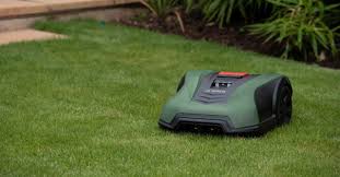
Bosch Autonomous Lawn Mower (Indego)
Following my work in autonomous vehicles, I contributed to Bosch’s Indego robotic lawn mower system, which brought sophisticated autonomous navigation technology to the consumer market.
Project Overview:
The Bosch Indego represents one of the first intelligent robotic lawn mowers that uses systematic
navigation rather than random patterns. The system autonomously maps lawn areas and executes efficient mowing strategies that reduce operation time by up to 40% compared to conventional robotic mowers.
Innovative Features:
- LogiCut Navigation: The Indego system autonomously maps lawn areas using advanced sensors and software, then executes systematic mowing in efficient parallel lines. This intelligent approach ensures complete coverage while minimizing energy consumption and wear on the lawn.
- Autonomous Mapping with SLAM: Implemented Simultaneous Localization and Mapping (SLAM) algorithms that allow the mower to build and maintain a detailed map of the garden while tracking its own position. The system understands boundaries, obstacles, and can navigate passages as narrow as 75 cm.
- Smart Scheduling: The Indego automatically calculates tailored mowing schedules based on lawn size and environmental conditions, eliminating the need for manual programming.
- BorderCut Technology: Each mowing session strategically begins with a perimeter cut to ensure clean edges, followed by systematic coverage of the interior area using the optimal path.
- Multi-Area Management: The system can save and manage up to three separate lawn areas in its memory, adapting to complex garden layouts.
Technical Implementation:
- Sensor Fusion: Integrated perimeter sensors (dual coils for wire detection), motor encoders for odometry, gyroscopes, compass, and obstacle detection systems to enable accurate navigation.
- Position Estimation: Developed algorithms combining odometry data with perimeter field strength measurements and map correlation to maintain accurate positioning throughout the mowing session.
- Energy Optimization: Created path planning algorithms that maximize battery efficiency by avoiding redundant coverage and optimizing movement patterns.
- Collision Avoidance: Designed bump sensor systems using hall effect sensors and motor current monitoring to detect and respond to obstacles safely.
Impact:
The Bosch Indego successfully demonstrated how advanced autonomous navigation technology developed for defense and automotive applications could be adapted for everyday consumer products. It made sophisticated robotics accessible to homeowners while maintaining high standards of reliability and efficiency, representing a significant milestone in the commercialization of autonomous navigation systems.
These projects represent my journey in autonomous navigation—from contributing to pioneering autonomous vehicle technology in the DARPA Urban Challenge to bringing intelligent navigation systems to consumer robotics. Both experiences involved solving complex challenges in real-time perception, sensor fusion, and intelligent decision-making in dynamic environments.

Leave a comment